

Hiking the spectacular Samaria Gorge in Chania
Surrounded by some of the most striking scenery in Europe, the Samaria Gorge trail, in Chania, includes abandoned villages and the rich wildlife of Crete’s White Mountains National Park
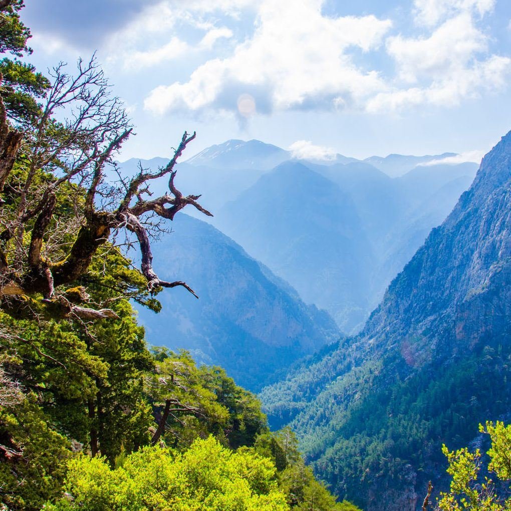
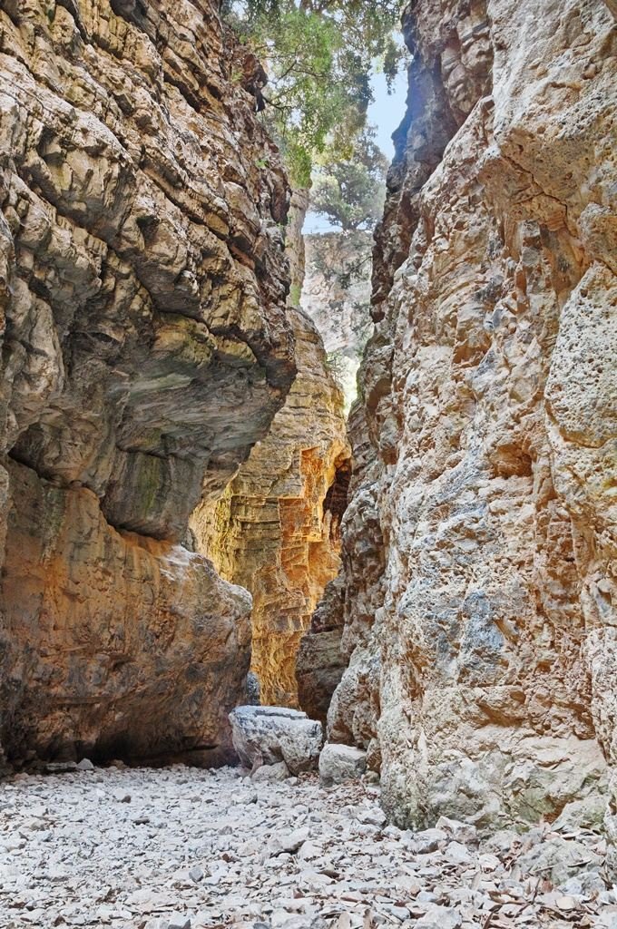
The Samaria Gorge, in Crete, has rightly become one of the iconic hiking destinations of Europe. The 16km canyon runs from a plateau beneath the White Mountains all the way to the Libyan Sea. It is the longest gorge in Greece and forms part of the E4 hiking trail that traverses Europe. But that’s just the start of an experience that has become a rite of passage for anyone wanting to explore the extraordinarily diverse region of Chania on foot. Containing 450 species of plant and animal life (70 endemic to Crete), the Samaria Gorge is a UNESCO-protected Biosphere Reserve. You will pass through forests of pine, cypress and holly trees, and by no fewer than 22 freshwater springs, as well as abandoned villages and churches you can pop into. The gorge itself is 150m at its widest but narrows to just 3m, with sheer walls of rock soaring skyward.
If tackled from Xyloskalo to the sea, it is downhill all the way. And although you crisscross a river multiple times – sometimes over wooden bridges, sometimes hopping from rock to rock – it’s not a difficult or technical hike. At the exit, you will meet Old Agia Roumeli and by car, you will now reach Agia Roumeli. The old Agia Roumeli was abandoned in the middle of the last century after a catastrophic flood when it was moved to its current location at the exit of the gorge. You will meet the beach of Agia Roumeli, which is located next to the village, and really there's no better way to celebrate the end of your hike, than with a deep dive in the clear blue and cool waters!
Duration
6-7 hours
Season
May-October


Visit Gouverneto Monastery
The monastery of Gouverneto is located in the Akrotiri peninsula, 19 kilometres northern of Chania and 4 km from the monastery of Agia Triada. The visitors should follow the road to Chania’s airport and then follow the signs for the monastery of Agia Triada. Gouverneto Monastery or Lady of Angels is one of the oldest monasteries of Crete and constitutes a sample of Orthodox monastic architecture. It was built in 1537 in an altitude of 260 meters by monks of the Catholic church that abandoned the place because of piracy. Its construction started during the Venetian period, but the works were interrupted during the invasion of Turks. The completion of the temple was achieved after many years and with a special authorization granted by the Turks. A paved footpath leads north of Gouverneto Monastery and into the Avlaki Gorge, which runs down to the sea. The descent is easy, but coming back is tiring if you’re not used to walking, especially on a hot summer’s day. It’s best to walk through the gorge either early in the morning or late in the afternoon. About 20 minutes’ walk from the monastery, you come to the famous Αrkoudospilios (“Bear Cave”), with the bear that was turned to stone and became a great rock inside the cave. Keep on until you come to the famous Katholiko Monastery and the church of St John the Hermit. Ten minutes’ walk further on is a tiny cove which was once used as a harbour. The aquamarine water would be very inviting for a swim before the climb back up to Gouverneto Monastery, if this were not strictly prohibited by the monks.
Duration
35-40 minutes
Season
All the seasons


Hiking Imbros Gorge
Imbros Gorge is located near Chora Sfakion and is the third most popular gorge in Crete. The scenery is beautiful and the low difficulty make the descent of Imbros ideal for families with children. The length of the gorge is 11 km and the course lasts 2-3 hours. The route starts from the small village of Imbros, 700 meters above sea level. Initially the course is descending and the sidewalls are relatively low. But while descending, the canyon narrows continuously, the sidewalls raise higher and the scenery is impressive. In many parts of the gorge, we meet traces of the old stone-paved trail that was once the main passage from Sfakia to Chania. Therefore, the canyon was a theatre of several battles between the Ottomans and the Christians during the Turkish Occupation of Crete, especially in 1821 and 1867.
Moving on, we cross the position called Airplane, where a German plane crashed during the Second World War (debris is housed in the war museum at Askyfou). Immediately after that, we encounter the first very narrow passages of the gorge and then arrive at position Gournia (i.e. basins), where there are several small basins in the rock filled with water in winter. After this we reach the most impressive part of the Gorge, Stenada. Here the gorge walls approach at 1.6m, while their height reaches 300m! The rocks are carved with very beautiful formations. After this narrow point, the canyon widens and we meet a resting place at position Mesofarango. Here is a Venetian water cistern and the hut of the guard of the gorge. After a few meters we cross a landslide and immediately after the impressive narrowing at Gremnaria.
Immediately after that, we meet another trademark of the gorge, the stone arch Xepitira. Continuing our journey, we pass through some narrow passages and soon reach the exit of the gorge by village Komitades. Just at the exit there are some taverns and in the village there are more options.
Duration
3-4 hours
Season
May-October

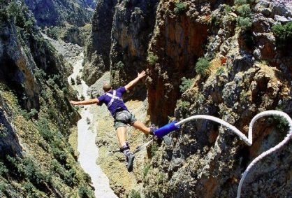
Bungy jumping in Aradaina bridge
Aradaina Bridge is 138 meters high and is located in the prefecture of Chania, municipality of Sfakia, Crete Island. It is the highest bridge for bungy jumping in Greece and the second highest in Europe. In 1999 the first jumps operated in Aradaina bridge when they set the Balkan record for highest jumps.
Aradaina Bridge is located 85 kilometres from the city of Chania - same distance from the city of Rethymno. Travelling to Aradaina by car or bike provides the chance to enjoy one of the most beautiful sceneries in Crete on a good asphalt road. Self drive duration one hour and fifteen minutes.
Season
June-September

Enter the world of diving
Have you ever wanted to try diving? How about snorkeling all in a very safe environment, and with the help of professionals? Enter the world of diving, and you will see something fantastic. The sense of zero gravity, breathing under water, full discharge from the stress of everyday life and the discovery of another world can only be noticed in autonomous diving!